Researchers at the Massachusetts Institute of Technology (MIT) have created a wearable device that automatically generates a map as the person wearing the technology moves around indoors. The creators of the wearable device expect the technology to be used by emergency teams when they enter unknown locations. The digital floor plan that will be generated by the first person to go inside a building can be used by other to navigate dangerous and unknown locations.
MIT ‘s Maurice Fallon, the lead Computer Scientist on the project stated that, “The operational scenario that was envisioned for this was a hazmat situation where people are suited up with the full suit and they go in and explore an environment, The current approach would be to textually summarize what they had seen afterward. ’I went into this room on the left, I saw this, I went into the next room,’ and so on. We want to try to automate that.”
The new technology is a large step forward after several robots have been created and showcased in the past for similar purposess. The robots had difficulty moving as fast and efficiently through a building but the self mapping devices had problems dealing with the natural walk of humans. The MIT researchers were able to solve these issues and create a wearable device that deals with the uneven gait of humans while also serving its purpose. It also has the ability to know when a human backtracks and accounts for that information in its map.
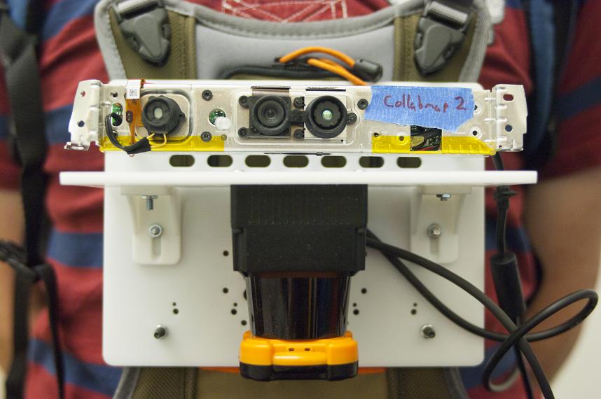
The device uses a number of sensors to do its job. The technology employs “accelerometers, gyroscopes, Microsoft Kinect camera, a barometer and a light detection-and-ranging device, or LIDAR.” The coolest feature is the LIDAR which utilizes laser beams that are sent in a 270-degree arc in front of the person to measure the distance of objects. This is done by measuring the time it takes for the lasers to bounce of the walls or other features and come back. The accelerometers and gyroscopes are used to detects turns and tilts, while the barometer helps the mapper detect changes in pressure. Interestingly, the device can also stay connected to a central computer that is not in the danger zone. It also allows the mapper to mark important spots if a button is pressed.
For now the device is too bulky for use and it will need to be shrunk down for real world use. Currently the large device is the size of a computer and the batteries must be carried along with the equipment.
Source: Mashable
Photo: MIT
 VIDEO: DARPA Creates Electronics That Can Melt in the Human Body
 Rogers Starts LTE Network Service In New Locations


 Lunches So Good Kids Can’t Ignore Them
 Invigorating Ginger Smoothie
 The U.K.’s Youngest Parents Ever
 The new hair Jennifer Lawrence