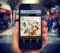
Google Maps has become one of the most significant innovations in the modern world, as it shows millions the best way to find a path or route that will lead them to their destination. However, a UK-based startup, Walkonomics has given mapping innovation a completely new dimension, introducing maps that will show a route that is the safest and cleanest.
The thought behind launching Walkonomics was to show users such routes that are rated high in terms of cleanliness, slope and safety, which other mapping websites do not value because their only preference is to display short distances. Noticing this gap led Adam Devies to found Walkonomics in 2011.
Adam Davies and his team will highlight slope, clean and safe routes with the help of publically-available data and user reviews in order to give various distances their walkability rating. This data for Walkonomics will be collected from public databases, which will depict the cleanliness, crime rate, road’s slope and a few other important factors. All these details are then aggregated to provide a particular score to a street, so user can find the best path that goes to its destination.
At this point in time, Davies and co have got the data for the majority of the streets in San Francisco, New York and London and are now working to get bigger by launching maps of North American cities and Toronto. Moreover, Walkonomics is also ready to launch their Android app that will work in combination with its website.
If Davies and his team will be able to pull such a thing off, it is expected to be a big hit, as till this day no one is offering such a service through which potential home buyers or other people can learn about a safe and clean neighbourhood in just one view.
Walkonomics is not an easy project to work on, as it requires plenty of data and lot of resources and form a platform that can create personalised routes. Furthermore, getting effective rating after collecting all the required data is another issue in the way of this project that sounds quite interesting at this instant.
Source: Pandodaily
 Barack Obama’s Victory Tweet Got Retweeted Over 500,000 Times
 Facebook Users Streamed 62.6 Million Songs Using its Open Graph Platform


 Lunches So Good Kids Can’t Ignore Them
 Invigorating Ginger Smoothie
 The U.K.’s Youngest Parents Ever
 The new hair Jennifer Lawrence