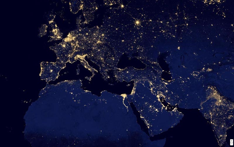
You may have come across numerous images of earth that have been taken from space spanning different hours of the day, but for the first time Google Maps is offering spectacular images of our wonderful planet after sunset. The effects are an absolutely stunning display which shows how the flickering lights of our world look to observers from above.
Google Maps has taken these images from the National Oceanic and Atmospheric Administration (NOAA) and NASA, who dubbed the photo set “Black Marble” after capturing these pictures from a jointly operated satellite, the Suomi NPP. The leading mapping service launched this global view of the world, which is an animation of different images on its website, Earth at Night late last week.
In its description of this global view at night time Google mentioned that “it took 312 orbits to get a clear shot of every parcel of Earth’s land surface and islands. This new data was then mapped over existing Blue Marble imagery of Earth to provide a realistic view of the planet.”
NOAA and NASA released the night time photos of our illuminated world last week showing the clearest view of our planet after sunset. To achieve this high quality result, NOAA and NASA not only required 312 orbits, but they also needed a very powerful Visible Infrared Imaging Radiometer Suite sensor to take these 2.5 terabytes of images.
Cloudless images were then separated from the others and stitched together onto the now famous “Blue Marble” images. Users can now view how different countries look on the Black Marble, as they can search from glowing New York City to the dropping lights in India and the darkness of the famous Sahara desert.
Source: Cnet
 Nasdaq 100 Adds Facebook, Bids Farewell to Netflix and Research In Motion
 Fit Brains Launches Trainer App for iOS Users to Train Their Minds on the Move


 Lunches So Good Kids Can’t Ignore Them
 Invigorating Ginger Smoothie
 The U.K.’s Youngest Parents Ever
 The new hair Jennifer Lawrence